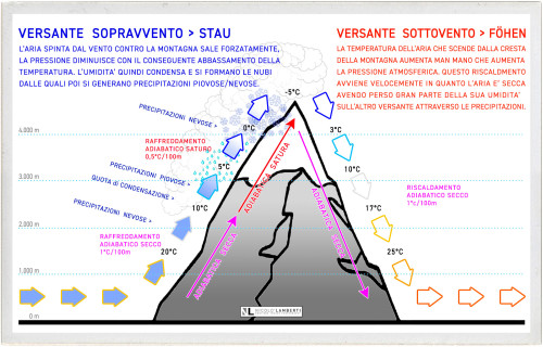
STAU e FÖHN.
When a mass of air mooving with a certain speed perpendicularly impacts against a vertical obstacle, such as a mountain range, the air mass is forced to rise (the movement of the mass of air is so fast that it has no time to have any heat exchange with the surrounding environment; in physics this is called adiabatic process).
Going up, as the altitude increases pressure decreases, the air mass will expand and the expansion will cause the air mass to cool until, once the dew point temperature is exceeded, the water vapor contained in the air mass will condense in very small droplets leading to formation of clouds.
The clouds will cause precipitation (as rain and / or snow) on the windward side. This is the STAU, a common atmospheric phenomenon in the Alps that can occur both on the southern slopes, when winds full of humidity arrive from the maritime regions, and on the northern slopes when the alpine arc is hit by cold winds from northern Europe.
After the mass of air has passed the mountain ridge, now dry as it has lost most of its moisture through precipitation, it will continue it’s way down to the leeward side. In its downward motion, since as the altitude decrease the pressure increase, the increase in pressure will compress the air mass with the consequent rise of it’s temperature. The result is a hot dry wind called FÖHN.
MOUNTAIN WAVES
In meteorology, Mountain Waves are a form of Lee Waves an atmospheric stationary wave. Mountain Waves are generated by the vertical motion that forces periodic changes in speed and direction of the air within this air current. They always occur in groups on the lee side of the terrain that triggers them.
As we have seen earlier, speaking about of the birth of the clouds, when a mass of air perpendicularly hit a vertical obstacle, it’s forced to rise upward. This vertical movement once overcome the top of the mountain produces a wave-flow of air that follows a trajectory characterized by ascending and descending motions. The Lee Wave that is so generated, stays motionless in comparison to the mountain and can produce vortexes (named Rotors), under the flow of the wave on the leeward slope of the mountain; this turbulences are very dangerous for small airplanes.
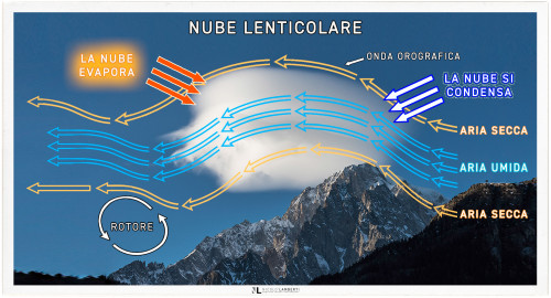
LENTICULAR CLOUDS
(Altocumulus lenticularis; Lat. - abbreviation Ac len)The mass of air that crosses the crest of the Mountain Wave, does an adiabatic process (an adiabatic process occurs without transfer of heat or mass between a thermodynamic system and its surroundings.) and generate a lens shaped well-defined cloud that doesn't produce any precipitation.
Dramatic Lenticular Cloud in a cold January sunset, over Monte Bianco, Italy,
Lenticular Clouds stays motionless in the sky in a leeward position respect the object that has produced the wave (in our case the top of the Monte Bianco). This happens because despite the moist particles of the cloud races very quickly, pushed by the strong wind, the points where moist condenses and evaporates doesn’t move because these two points are perfectly still comparing them to the mountain.